Monday, December 3, 2007
Shredding Mail
I'm Leaving Camp Speicher today to go to Baghdad to learn to be a mail shredder. If you get mail from Iraq that is torn or damaged, you might be able to blame me. I'll be working with the uncle of Garfield (the comic strip cat), who has been responsible for most of your damaged mail in the States up until now.
Thursday, November 29, 2007
Fun Patches
Here is a photo of the patches I am going to put on my paragliding harness. I may also try to pick up a couple more and put on my hang gliding harness. Linda, my wife, posted the photo for me. I still don't have a camera here, and no way to upload photos here yet.
Friday, November 16, 2007
Improvements
I'm settled into the new digs, and things are looking up. My new room mate is from Bosnia, and is tolerable of the cooler temps I prefer for sleeping. He said he would prefer we turn the A/C unit off, as it is a window unit and somewhat noisy, which is very much OK with me. I was at the billeting office this evening, and the woman who had not been overly friendly asked how things were now, and I told her it was excellent, and my room mate was standing there in the office. She did the "YESSS!!!" thing with the arm motions and all, when I told her I had a great room mate. Things are definitely better over here now than two years ago.
On another note, I noticed when I was logging in, the last post showed something like 3:45 am as the time when I posted it. If I can find where to adjust the time, I will get it changed to my local time, instead of the time at home. Currently it is ten hours later here than it is at home.
Smooth Air, Long Flights, and Soft Landings.
Thursday, November 15, 2007
Patented Weight Loss Program
I started my patented weight loss program yesterday, and am having second thoughts about it this afternoon. If I wear my waistcoat around all the time, I'll lose weight! The waistcoat is covered by one or more patents, so I call it my patented weight loss program. I may start wearing it every other day, until I get a little more used to it, then go back to wearing it every day. It is one of the newer technology "lighter weight" systems, and only weighs about thirty or forty pounds. There are some of the guys here who claim theirs weighs upwards of sixty pounds. In case anyone isn't familiar with what a waistcoat is, it is a vest. I'll give you three guesses, as to what kind of waistcoat they give me to wear over here.
I also would like to add my supervisor told me if I needed to sleep somewhere other than my cheesebox because a roommate might think they have to have it waaaaay too warm, I should be able to find a cot out here. That way, I could sleep inside the bunker, instead of on top of it, and be able to stay cool, and keep everyone happy all at the same time. He also said if I had any problems with billeting, to let him know, and he could probably take care of any problems with them.
I also would like to add my supervisor told me if I needed to sleep somewhere other than my cheesebox because a roommate might think they have to have it waaaaay too warm, I should be able to find a cot out here. That way, I could sleep inside the bunker, instead of on top of it, and be able to stay cool, and keep everyone happy all at the same time. He also said if I had any problems with billeting, to let him know, and he could probably take care of any problems with them.
Wednesday, November 14, 2007
Busted!!!
Jon, the music is more boring now. The dance floor is smoother, and the band did not spend as much on pyrotechnics as they did at the previous ballroom where I went dancing. Thanks for commenting. I was beginning to wonder if I was typing this for myself, and no one was reading it.
On to the reason for this new post.
There I was sleeping soundly on top of my own concrete bunker, curled up in the sleeping bag the company had issued to me, with my head laying on the pillow they had issued to me, on top of my Turkish rug I had purchased yesterday, and some guy starts waving a flashlight at me and saying "SIR, SIR, SIR!!!" Turns out someone had said something to the wrong people about someone sleeping on top of a bunker, and there I was - BUSTED!!!
They did give me the keys to a differrent room that only has one person in it, and he had turned the heater off because it was too hot. And, it wasn't anywhere nearly as warm as the room I had slept in before I moved my sleeping arrangements to the top of the bunker. I also have an extra comforter I can give the guy in there in case it is too cool for him, as the new room had bedding for the new occupant in it, and I don't need any additional stuff. I think I will keep the good sleeping bag and pillow, just in case I might need to find alternate sleeping arrangements again!!! If I get on top of one of the cheeseboxes, and have the cooperation of whoever is in there, no one will see me!
CheeseBoxes
I went to a formal ball and we had to stay an extra day due to low visibility conditions from dust. When I got back, I dropped my stuff off at the cheesebox. I use the term cheesebox because that is what they called similar living quarters when I was at Anaconda two years ago. The cheeseboxes at Anaconda were a forty foot long container with a door and a window unit air conditioner at one end. The Anaconda cheeseboxes had 5 cots in them. The cheeseboxes here at Speicher are a twenty foot long container, and have two bunk beds in them. I had heard that at one time Anaconda had five bunk beds in their cheeseboxes. I can't imagine how bad that would have been.
When I got back from the ball, I dropped my overnite stuff off there and went to the PX to get a foot locker to store my waistcoat, party hat, ballroom dancing gown and gloves, and sleeping bag for the truck so I would not have to pack the stuff out here to work every time I went dancing. When I dropped the stuff off, there were three new people in my unit, and they had the heat set to about eighty five degrees. I turned the heat down, but did not turn the unit to air conditioning. After returning from my trip to the PX, and then dropping the foot locker off and putting my stuff in it at work, I noticed someone had removed the temperature control knob, and it was back to eighty five degrees in there. I went to billeting, and filled out a work order to get stuff fixed, with a notation that the knob had disappeared in the two hour time span between my first visit, and my final return. I also checked out another sleeping bag and a pillow. My plan was to sleep on top of the concrete bunker in front of the cheesebox. I had bought a Turkish rug while I was at the location of the ball, and tried to sleep on the concrete bunker without it. After a couple of hours tossing and turning, I went back inside the cheesebox and retrieved the rug, and placed it under my sleeping bag. It was much better after doing this. The temperature was about fifty or fifty-five degrees, and the sleeping bag was plenty warm. It was definitely better than sleeping inside the hot cheesebox.
Unless things change about the temperature in the cheesebox, I plan to continue sleeping on top of the bunker. I haven't decided what to do about waterproofing when it starts raining in a couple of weeks, but I am sure I will be able to figure something out before the rain starts.
Supposedly the cheeseboxes are a temporary deal, and people are moved into the dormitory, based on seniority of time in country. However, there was a new arrival today who left Houston two weeks after me. He was placed in the dormitory today, his first day here.
Wednesday, November 7, 2007
Camp Speicher
I made it to Camp Speicher yesterday, and am sleeping in temporary housing for the moment. We did some orientation and driver training today, and will probably start doing some driving moving stuff around on the base tomorrow. We have orientation to the "C" sites on Friday, then should be able to go out on a convoy some time after that. The first trip out will be a "right seat, left seat" deal, where we ride along with another driver who has been at this base a while, to wherever we are going, and we drive back to here. Then we will be allowed to drive on convoys without any one else in the truck with us. I'm looking forward to getting to work. I currently don't know if I will be staying here, or if I will be transferred to another base. If I get transferred, it will most likely be to another of the "C" sites. They have "A, B, C, D, etc" sites over here, and the number one of each group is the primary base of the group. I don't have a clue as to why the sites are grouped this way, as it does not seem to be geographically sorted.
Hope everyone is well.
Smooth Air, Long Flights, and Soft Landings,
GliderMike
Hope everyone is well.
Smooth Air, Long Flights, and Soft Landings,
GliderMike
Monday, November 5, 2007
Traveling to Baghdad
Had a break during the festivities involved to travel to Baghdad, so I thought I would do a quick post. Yesterday, we spent the day "outprocessing" to get ready to transfer to Camp Speicher. Part of the process involved, checking in our Level III waistcoats, along with NBC gear, as we can get new stuff when we get to Speicher, and avoid having to carry an extra 50 or 60 pounds of stuff while traveling. I hadn't remember how far it was to where I needed to check in the Level III stuff, so I also wore my Level IV waistcoat on the walk. I would need to let someone else verify by inspection what the GP (government property) number on my Level IV vest, so I thought I would take it all with me. I was soaked and concerned about heat stroke by the time I got there to drop off the NBC gear and Level III waistcoat. One of my friends had done the same thing, and I guess he isn't in as good physical condition as I am, so he was in trouble! He walked in, and started slinging stuff off, and was cussing (quietly, but loud enough I and the guy who was checking my stuff could hear him). When the vests hit the floor, they were clanging (steel and ceramic bulletproof plates in the vests, remember), and making a racket. I started laughing about the circus, and when Mike noticed me laughing, he got embarrassed and said "It slipped", which caused me to start laughing more. I was nearly rolling in the floor when he said that, and all three guys in the warehouse were laughing by now. Mike finally calmed down, and he started laughing. I told him later it was mean of me to laugh at him, and he said he thought it was all pretty funny now that it was over with.
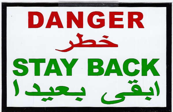
We made it to Baghdad on the 5th, and overnited there. I bought some stuff at the Bazaar outside the PX there. I bought decals that say "Danger, Stay Back" written in English and Arabic, and a couple of patches saying the same thing to sew on my Hang Gliding and Paragliding harnesses, as well as some postcards. I also bought a fabric map of Iraq which is supposed to be a "survival" map in case you get separated from your convoy. AND, I bought a couple of patches for OB1, and Montana Jeff to put on the boots of their harnesses which say "American Convoy Ahead, Stay Back" If they are flying good at the comps, it will be a moot point, but if someone is catching them, maybe it will break the concentration of OB1 and Jeff's competitors, knowing they should stay back! It is a good thought anyway, and the guys should be able to get a laugh or two out of it, if nothing else.
We made it to Baghdad on the 5th, and overnited there. I bought some stuff at the Bazaar outside the PX there. I bought decals that say "Danger, Stay Back" written in English and Arabic, and a couple of patches saying the same thing to sew on my Hang Gliding and Paragliding harnesses, as well as some postcards. I also bought a fabric map of Iraq which is supposed to be a "survival" map in case you get separated from your convoy. AND, I bought a couple of patches for OB1, and Montana Jeff to put on the boots of their harnesses which say "American Convoy Ahead, Stay Back" If they are flying good at the comps, it will be a moot point, but if someone is catching them, maybe it will break the concentration of OB1 and Jeff's competitors, knowing they should stay back! It is a good thought anyway, and the guys should be able to get a laugh or two out of it, if nothing else.
Saturday, November 3, 2007
A Beautiful Day in Paradise
I finally arrived in Mesopotamia between the banks of the Tigres and Euphrates Rivers on October 20. I spent the night at the Baghdad Transition Center, then on to Camp Anaconda on Sunday, October 21 (my birthday). I celebrated my birthday by having a chili cheeseburger, onion rings, and a strawberry sundae for lunch, then having a banana split for my evening meal. I leave for Camp Speicher in a couple of days, where I will be posted (until someone decides they need more truck drivers at some other camp) for at least 120 days.
The company seems to have improved since the last time I was here, and everything seems to be a lot more positive now than before. Now, after you have been at a location for 120 days, you can apply for a transfer to another base, and they are allowing the transfers to happen. I think the improvement in attitudes and treatment is due to the current Project Manager, who is extremely emphatic about company policy of dignity and respect. He spoke to us (truck drivers) the second day we were here at Anaconda, and seems to be a straight shooter, who doesn't talk out of the side of his mouth, if you know what I mean.
Today I checked out a new level IV waistcoat, along with a ballroom gown, gloves and headdress to wear when I go ballroom dancing. The gown, gloves and headdress are made of Nomex fabric, and should be quite stylish, except for the fact everyone else will be wearing the same thing! The day I arrived at Anaconda, I was issued a tiara to wear to the dances, but it seems to be fairly heavy. Many of the soldiers refer to their tiara as Kevlar. Hope this finds everyone well. I am doing well, as I got paid for the first last days of October on November 2, instead of November 16th. During orientation they had told us we wouldn't get paid until later, as we had arrived in country after October 15th. I had the good sense to not complain about being paid early. Some of my friends from Kenya are starting to arrive here now also, which gives me more opportunity to practice the few words of Swahili I learned in Houston. There are also some Ugandan soldiers here who are also helping me learn my new language. Having a good time, wish you were all here. The house thermals look promising for flatland flying.
Smooth Air, Long Flights, and Soft Landings,
GliderMike
Friday, October 19, 2007
Finally out of Houston!
I finally left Houston on the 17th of October. I had been within three hours of getting on the airplane to leave on the 9th, and they told us someone had contracted chicken pox. The guy had went to a doctor there next to the hotel on Friday, and done blood tests that confirmed the infection. He started showing the bumps and stuff on Monday after that, and called the company people. They sprang the news on us Tuesday morning. I couldn't remember if I had ever had chicken pox or been exposed to it enough to have an immunity built up, so I did what I thought was the 'honorable thing' and did a blood test the next day. I didn't get out of Houston for another eight days. When I get to feeling sorry for myself about having to hang around so long, I remember a guy from Kenya who had been there two weeks longer than I, and he ended up in quarantine until October 26. Hopefully none of the twenty or thirty people who ended up in quarantine came down with the chicken pox, which could cause them to have to stay even longer.
Sunday, September 23, 2007
A Piano Player in New Zealand
I think I have all my projects done, and have about 15 minutes of "last minute packing" to do, and I will be ready to go to Houston to start orientation to go back to Iraq. When I was in Iraq before, I had started a blog, but immediately forgot the password, and never posted to it. I have decided to use it for the stories I will have when I am "off base", and use this blog for stories of "inside the wire". I have a link to it in the links section. The blog is www.nzpianoplayer.blogspot.com and the link I have listed is for A Piano Player in New Zealand. The title of this post is not to be confused with the link. I have a little story about what I will be doing with the blog, and another little blurb about someone else who claims "piano player in a brothel" as their occupation. According to blogger, he is the only other person who has a blog, claiming that occupation other than me. AS most of you know, I have been using that phrase in various places for quite some time, even before I went to Iraq. I added the NZ part when I went over there. Photos may be scarce for a while. Thanks for all your support.
Smooth Air, Long Flights, and Soft Landings,
GliderMike
Smooth Air, Long Flights, and Soft Landings,
GliderMike
Saturday, September 22, 2007
Ben Lomand Peak September 18, 2007
 This is "Oregon" Steve Siebel on his first trip to Ben Lomand Peak. The drive up was an hour and a half of dirt road. When we got there, Steve was wondering what he had gotten himself into. You can see the "Intimidator" in the center of the photo. I had warned him about it beforehand, and told him it really is not a problem, but due to its size it really looks intimidating. It is about three-fourths of a mile out there to it.
 These two photos are of some mountain goats we shared the ridge with. They didn't seem to be bothered by us. I flew over them later, probably three hundred feet above them, and they didn't seem to pay any attention.
 This is a shot after we all landed with the "Intimidator" and launch in the background. I had launched first, followed by Oregon Steve, then by Crazee Mike. I flew for an hour total, getting about thirteen hundred feet above launch. I could see Logan, Eden, Brighan City, and Ogden all at the same time. This was the best ridge lift I have ever flown, as I could get nearly a mile out in front of the top of the ridge, and thirteen hundred feet above the top, and still was in good smooth lift. It took me twenty minutes to get from the high point to the LZ I chose. I probably traveled three or four miles up and down the ridge sightseeing. The LZ I chose was a freshly plowed alfalfa field, which was not as good a choice as the freshly cut alfalfa field next to it would have been. When I landed, what little wind there was, was behind me, and I couldn't run the landing out fast tenough to keep from putting the nose of my glider in the dirt, and bent a down tube. When Mike landed next, he landed in the cut field, and did better, having a two mph headwind. Steve landed in the plowed field, but he also had about a two mph headwind, when he landed. I flew for an hour total as I mentioned earlier, Steve flew two hours, and Mike flew an hour and forty five minutes. It was a good day, in spite of my bent down tube.
 This is a shot I took before sunset, after we had packed everything up.
Monday, September 10, 2007
Lots of Hang Gliders on the North Side
John, Shadd, Dave T. and I painted the new ramp at Pete's today. It really looks good. I will give the deck an additional coat of paint tomorrow afternoon to finish it off.
There is a group from Wisconsin visiting this week, and with the combination of them and a large number of locals showing up this evening, there were about 15 or 20 hang gliders in the air this evening. It was breezy enough that there were only 2 or 3 paragliders up for most of the time. Conditions looked slightly cross at launch, but when I launched, it was definitely a Viagra day.
I was visiting with Dangerous Dave this evening, and we decided to do a Mastercard commercial that goes something like this:
New top of the line, state of the art racing glider - $7,000.00
New Instruments/GPS navigation system - $2,000.00
New State of the art, top of the line, super aerodynamic racing harness - $1,500.00
Latest super high fashion, super aerodynamic hang gliding sunglasses - $300.00
Your buddy seeing the whites of your eyes on both sides of the said sunglasses when you are launching on the first platform tow you have done in 15 years - PRICELESS!!!
Tuesday, September 4, 2007
Flying the North Side
I flew the North Side this evening on my Paraglider, and Linda took a bunch of photos. I'm still experimenting on how to upload photos. The first group of photos are in reverse order with the later ones at the top and the earlier ones below the later ones. There are two groups of photos, and each group is in reverse order. Captions for photos are below the pertinent photo(s). It was a good evening on the North Side for me.


 Linda was able to get 3 shots of Dude and I close to each other. I talked to Dude afterwards, and I think he was a little tense on a couple of the passes we made. He was able to stay up almost as long as I did, and he also was able to top land. At one point, he was within 50 feet of having enough altitude to bench up. I lacked about 100 feet ever getting enough altitude to feel comfortable enough to move back to bench up. There were quite a few people who did bench up, but they launched about twenty minutes before I did, and the lift was starting to fall off a little by the time I launched. There were also quite a few people who sank out and landed in the water treatment plant LZ.
 The "house thermal" in front of the HG launch was really cooking this evening most of the time.
 Here is a photo showing my excellent form pulling my wing up getting ready to launch.
The below photos are in reverse order, with last being at the top and the earliest of this group being at the bottom. Yes, I really was that low, and yes, I really did get back up above the ridge, and top land.
 The order is reversed on this group of photos. My smile is so much ear to ear here, you can't see much curve on it. This was after I top landed. There were a bunch of people who sank out.
 I never did quite get high enough to feel comfortable to move back to bench up, but it was close.
 There were times traffic was a little thick.
 I was actually getting back up here.
 I really did get this low. Linda said my wing never got below the ridge, but I knew there were a couple of times I really got low. When I would hit some good lift, I'd check traffic, and if it was where I could make a couple of turns to pick up a little altitude, I did. It was a good evening for me on the North side.
Sunday, September 2, 2007
Ben Loman Peak September 1

Mike Gretta and I flew Ben Loman Peak (or Willard Peak, not sure which it is) north of Ogden this afternoon. This is a shot looking down the south facing launch. I call the large rock point that is slightly to the left of center "The Intimidator." Standing on launch, it looks a lot closer than the 1/2 mile away it is.


Above is Mike Gretta ready to launch, and after launching. You can get a better idea from the "after launch" shot of why I call the point out front "The Intimidator" The three below photos are me before launching, and 2 more after I am out, but still between launch and "The Intimidator". These really give a perspective of how far out the big rock point is from launch.


These 3 photos are in the order they were taken from left to right, and down. On the lower shot, I am still between launch and "The Intimidator." It REALLY is a long way out to the big rock point.
The LZ I chose was an elongated bowl between two sets of powerlines. The bowl was about a quarter mile wide from east to west, and about a half mile long from north to south. I didn't take any photos of the LZ. (I need an emoticon here, and haven't figured out how to put them in yet!) The bowl was about twenty feet higher on the north end than the lowest point, and about fifty feet higher on the south end than the lowest point. The lowest point, where Mike and I actually landed was at about the two-thirds distance point from the north end, with the last third of the LZ to the south of us. This was my "first" time to pick an LZ from the air that I knew wasn't flat, and only my second time to pick an LZ from the air, which I had not checked out on foot before the flight. I chose the LZ for relatively easy access for retrieve, and because I was sure I could end up heading uphill at the moment of touchdown. There were also some leafy trees over the very north end that I could fly over to check wind direction by looking at the leaf movements, and still be high enough to land to the north or across the LZ if the surface wind was not still out of the south. My skydiving background helped with this, and my ballooning background helped with a "guestimation" of wind speed. I was pleased with my LZ choice. You pilots who have lots of XC time may not remember what it was like on your first few flights when you had not actually picked out your LZ before launching. This LZ was not visible from launch, as "The Intimidator" and the ridge it was in kept us from seeing this LZ from launch. Next I have some photos I took after we landed, but none of the actual LZ itself.
 This gives a whole new meaning to "going in the bushes!" The LZ was behind "Willard Bay Nursery"
 This photo shows my harness, helmet and "packing tool" in the shade behind one of the shade bushes in the area. I have a close friend who gives me a hard time about my not caring for lots and lots of trees. He likes lots of trees for the shade available from them, and I tell him you don't need so many trees to be able to find shade. This shot is for him. I'm not sure if you can recognize the packing tool is a bottle of NewCastle.
As you can tell, I'm still learning how to place my photos in the blog, so some are not as nicely placed as OB1 or Jamie Shelden do theirs, but at least I do have some photos. It was a good day. This flying site, could be a H2 site, except for "The Intimidator", the power lines on both sides of the LZ, and the fact you can't see the LZ from Launch. The day we flew it, I don't think it was a "Big Air" day, but the site definitely has the potential to be a good XC site, and a good "Local Big Air" site, with lots of available altitude. The drive up is longer (and definitely requires 4X4 with good ground clearnance) than the drive up Francis Peak (which is driveable with almost any two wheel drive), but there are not the altitude restrictions here that Francis has. Mike and I have discussed the day, and both came to the conclusion it was a good exploratory day, learning some of the areas to be able to get good lift, and some of the areas to avoid, unless you are wanting some sink. I'm not sure exactly how much vertical launch is above the LZ, as I didn't check altitude before starting up the hill, and didn't zero my memo altitudes before launching. I think it was around 4500 feet vertical from launch to the LZ. Also, Linda Watkins (my wife for those of you who don't know her) took the photos shown on this post.
Wednesday, August 1, 2007
Looking for Work Again!
I bailed from the dump trucking job, and yesterday was my last day. Trying to figure out what I can find in the way of gainful employment that doesn't have much to do with trucking. Preferably looking for something that has to do with aviation of some sort. I hope to never set foot in a truck in the states again.
Tuesday, July 31, 2007
Friends

 Photos of a gaggle of gliders waiting for conditions to improve to launch at Bauer.
Sunday afternoon July 29, Shadd, John Russell, Crazee Mike, Sam Cox, Liz Holt, Berg, myself, and David, a friend of Shadds who drove for us, went to Commodore to fly. Most of us set up, and felt the wind at our backs for an hour or so. We had a discussion, and decided to move to Bauer for the evening glass off. We all set up, and watched Crazee Mike do a nice sledder in the Swift. Mike got the longest flight of the day. After Mike packed his glider up, we stood around some more, waiting for it to get better, and I decided it was soarable. I launched, and went nearly to the train tracks at about 20 ft above the ridge. When I turned to head back, I got below the ridge, and never got back up. I kept trying to milk it for all I could, and ended up with not enough altitude to make any of the more desirable lower LZ's, landing in the sagebrush about halfway between the mowed "landing strip" and the clear area to the east where Shadd landed a few minutes later. Shadd launched next, and got a slightly shorter flight than I did, but he did make it to a desirable LZ. Liz launched next, and conditions were even worse for her. She got one little pop that extended her glide enough to make it into her regular LZ. Berg arrived shortly to pick her up. David had arrived to pick Shadd up shortly after he had landed. I had left all my bags, velcro ties, etc at the top, so I wasn't able to start bagging my stuff until David arrived (graciously with my bags). Shad and he had things to do, so they asked if I would be able to ride back up with Liz and Berg, who were around a berm from us.
I said "Sure, no problem" without checking to make sure they were still there. My mistake # 1.
After getting my stuff bagged, and gathered together, I went to ask Liz and Berg to swing back by and pick my stuff and me up. They were gone. I went back to my stuff, watching for any sign of activity at the top. Forgetting I am with a group of friends who have the same attitudes as I do and you make sure everyone is accounted for with their rides, I get ready to start hiking for the top. I like to blame thoughts like this on my high percentage of gray hair in addition to the lack of Newcastle I had with me at the time. My mistake # 2.
I get the only Newcastle I had brought on the expedition (My mistake # 3), which I had placed in Shadd's cooler earlier in the day, and finished it about the time I was at the halfway point.
Looking at the empty bottle, I try to decide to continue to be a tree hugger and pack it out, set it down, or see how far I can toss it. The tree hugger won, so I carried the bottle with me. When I finally top the ridge, I see the Hajjimobile at the other end of the ridge starting down the hill to come and get me. It is at least a half mile away from me. I had started waving my empty Newcastle bottle when I topped the ridge, hoping it would catch a glint of sunlight (I was still in the sun at this point) so whoever was driving the Hajjimobile would see me before they started down the hill. When I get within 300 yards of the 3 people next to the cars, I realize through a process of elimination, it is Liz who is driving down. When Berg, John, and Sam see me, they all start laughing, with Berg laughing so hard he is rolling on the ground. Having had one Newcastle during my hike up the hill, I can see SOME humor in the situation. I would have been able to see a lot more humor, had I had two Newcastles. I also know that Liz (one of the most congenial people I know), not having had a Newcastle, (even though she does bring some very fine brew) will probably see no humor at all in the situation when she arrives at my stuff and I am not there. By the time I get to the guys, they have settled down, Berg is no longer rolling on the ground from laughing so hard, and John is not bending over from laughing so hard. We discuss whether Liz will be able to load my stuff or not, with mention made of her comments earlier in the day that she can load her own glider by herself. I then remind the guys that my glider weighs nearly twice what her glider weighs, so we decide John should call her. Liz did QUITE an ADMIRABLE job, and IN SPITE OF NOT HAVING a Newcastle or three, she is able to laugh about it all. I felt bad about her packing everything up for me, but not bad enough to go back down there to help her!
When she got to the top, she asked why I didn't call anyone. I said I had left the phone in the Hajjimobile, at which time she mentioned she had tried to call me when she arrived at my stuff, and my harness started ringing. OOPS!!! I think I owe Liz quite a few Newcastles!!!
Even with everyone who flew getting only sledders, Liz making the decision she REALLY likes the light weight of her new Falcon 3 (she knew this already, but loading my Northwing T2 reinforced it), and me hiking up the hill, we all decided we had a good time, and it was definitely better than a good day at work.
I have some of the best friends in the world in the hang gliding community.
Friday, July 27, 2007
In Search of the "V"
This evening (Thursday), after I got off work, I went to try to find Launch at the "V" above Bountiful. Someone had told me to take Skyline Drive and it would put me at the "V". They told me I would run into Skyline Drive if I went east from the 400 North exit at Bountiful off I 15. Thirty miles later, I am coming down the road that runs up Farmington Canyon. More than half the drive was in the dark, as I didn't get done with work til nearly 8pm, instead of the 5:30 I had hoped for. At one point, I was nearly as high as launch for Francis Peak, and another time I could see Ogden to the west and Morgan to the east. This would be a nice scenic drive to do sometime when flying is not an option, but it wasn't what I had in mind for this evening. I saw a guy on a bicycle riding up the road, and he had probably done 10 miles up the hill when I saw him. If I had turned around and went back down the way I went up, I was going to ask him if he was training for the "Leadville 100". If you haven't heard of it, the Leadville 100 is a 100 mile mountain bike race that starts and ends in Leadville, Colorado, elevation 10,000 ft or thereabouts. It never gets below 8,000 ft, and I think it goes through 12,000 several times. Maybe even 13,000 ft. If you haven't walked around at 12,000 ft in a while, let me remind you there isn't much oxygen there. If I ever find launch for the "V" I am going to take photos, and maybe get someone else to take photos of me launching from there.
Monday, July 16, 2007
Things are looking UP!
I got to fly this morning for the 3rd day in a row. A record for me in the last two years! And I just realized the 3 days were at 3 different sites! Paul Voight from New York graciously gave me a shirt from a "fly-in" they had in 2004 at Ellenville, NY, and it came yesterday. The shirt is Pink with Blue screening on it, and matches my glider! I wore it today, and it was great. I got to the South side late, and John and Guy Lindbergh were still flying, and it was starting to get a little rowdy. I started setting up my glider and the wind was strong enough I couldn't get the sail tensioned. I started to pack up, and decided to wait a few minutes before putting the bags back on the glider. The breeze eased up, I moved the glider 20 feet farther back from the edge of the hill, and turned it sideways. I re-started the set up process, and within ten minutes I was ready to get my harness out, hook in and fly. I launched, and flew for about twenty minutes. For the first few minutes of the flight, there was a red tailed hawk in the air with me. It seemed like he was spotting the thermals for me. A few minutes later, there was the same hawk, and I think a Kestrel. A few minutes later, there were two red-tailed hawks in the air with me. I have been able to fly a few times when one of the "Locals" was the only other one in the air with me, but this was the first time I had ever flown with two of them. It was really special to have been in the air with three different locals, with both combinations of two of them in the air with me. As I was starting to drive away, I got a phone call about a job possibility, that will be acceptable pay, and also have the possibility of starting to work tomorrow. If it works, the next several months, I will be working six days a week, but the extra money will help things out.
All in all, a GOOD day!!!
Did the interview for the job, and I think it will work well for me. I'll be driving a dump truck, and will be starting on the evening shift, working from 4:30 pm til 2 am, which actually works good for me. I have difficulty getting up four cracks before dawn if I'm going to go do something important, like flying, and sure enough don't to want to get up that early to do something like work! The owners of the company, Tom and his wife Joanna seem like good people, and I think I will enjoy them. Joanna is interested in trikes, so we might be able to get someone interested in aerotowing us!!! Things continue to look up!!!
Monday, July 9, 2007
Looking for Work


I quit the over the road trucking job June 30. The communication problem seemed to be getting worse, and I couldn't deal with it anymore. The money had been falling off, and putting up with the poor communications weren't worth it anymore.
Photos are shown in the order I took them starting left to right then down and left to right. The first two are of the Hajjimobile with all the stuff I had in the truck, plus my glider, the Northwing T2 I bought from OB1, the Santana tandem and my Bianchi road bike which wouldn't fit in the truck. I carried my HG harness, and my complete PG rig with me.
The Canadian Escarpment sign photo was taken southeast of Las Vegas, New Mexico. I had hoped there would be a site suitable to launch one of the gliders and get a flight in on the way home. I should have gotten the altimeter out to check the vertical rise from the valley floor to the top, and spaced it. There is more than one highway which climbs up onto the escarpment, but I don't recall if any of the other roads have a launch site that would be easily accessible. I would estimate the vertical to be fifteen hundred to two thousand feet above the valley floor.
The photo with all the trees is south of Taos, New Mexico. I stopped in Taos and had lunch at Michael's Kitchen, undoubtedly the best Mexican food in Taos. Their food is so good, you can have it without having a beer to go with it. They don't serve any alcoholic beverages there, and they still stay very busy. Michael's is a couple of blocks north of the Square in Taos, on the west side of the highway going thru town, if you ever get a chance to stop there.
The next two photos are from the Rio Grande River Bridge west of Taos, where I made my second bridge jump in 1982. The LZ I used is the triangular shaped area in the center of the photo. It looks pretty flat, with not much obstructions from 700 feet above. Looks can definitely be deceiving.
The Buttes are the Brazos Buttes, which are west of Taos on US Highway 64, about fifteen miles East of Tierra Amarilla, New Mexico. I camped out at a picnic area overlooking these Buttes at the site where I took this photo of them the night before I jumped the Rio Grande Bridge. The Aspen trees in the area are currently plagued with web worm, and appear to be dieing, which is really sad to see. This area is definitely one of the prettier parts of Northern New Mexico, in my opinion. This range extends north to Cumbres Pass, where you can ride the Cumbres and Toltec Narrow Gauge Railroad that runs between Chama, New Mexico, and Antonito, Colorado. I think the scenery on this train is even more fantastic than the scenery on the Durango train, sixty five miles West of Pagosa Springs, Colorado.
The next photo is of the sign marking the Continental Divide where US 64 crosses it west of Chama, New Mexico. North of here along the Divide (about fifty miles) is Wolf Creek ski area in Colorado, where they usually get some of the most inches of snow in the lower forty-eight. Most of the "Fourteeners" in Colorado aren't very far off the line of the Divide as it moves north.
I got back to Salt Lake Tuesday evening July 3, and stopped by the Point on the way to the house. I had flown at Wallaby Ranch the week before, and the velcro on the lower zipper on my HG harness wasn't holding. I had replaced the zipper some time back and used 1 inch velcro, instead of the regular 2 inch velcro. I had tried to "knee out" before I took the zipper out, and wasn't able to break it loose, so I thought I would use 1 inch instead, and it wasn't holding anymore. I got in a nice 45 minute flight on my paraglider. I had bought the G Sport from Dale Covington over Memorial Day weekend, so now none of my gear is borrowed. I slept most of the day on the 4th, then flew my hang glider Friday morning after adding more velcro to the zipper. A group of us were going to do some platform towing on Saturday, but the 2nd pilot to launch had problems and ended up in the hospital. My theory is he went thru a fairly large dustie immediately after launch, and couldn't compensate enough to overcome the problems the dustie caused. He doesn't remember exactly what happened yet, so we don't know for sure what the exact cause was. Hopefully he will eventually regain memory of the incident, and shed some light on it. Memory loss is pretty normal if there is head trauma involved on a deal like this. I hope to get the photos from the camera downloaded sometime soon, and update some of the older posts awaiting photos.
While I was at Wallaby, I was visiting with Mike Barber, and he commented "I won't live somewhere that has a traffic report." Traffic within a 15 mile radius of Wallaby is usually light enough that there is no need for a traffic report. The last time I was in Washington state, it seemed like most of the state was laid back enough that it might be possible to not feel the need for a traffic report, even in Seattle! I attribute the phenomena to the use of medicinal marijuana. Use is common enough to offset the crack in the public water supply. I think there is a conspiracy among the auto manufacturers, oil companies, and auto repair people to put large amounts of meth or crack in the public water supplies in most of the United States. This causes people to drive in various states of altered consciousness, creating more sales for each of the three groups. The various medical related businesses and professionals may also be involved in this conspiracy. I think the insurance companies are receiving kickbacks from the people involved in the conspiracy, also. Of course the insurance companies keep raising their rates to compensate for the increased costs, so they may be gaining profit also, and be directly involved in the conspiracy.
Drive safely, the life you save could be mine!
Write if you find work!!!
Monday, May 21, 2007
Still Working, The Cadillac Ranch, and Devil's Slide

 Two of these photos were taken at the Cadillac Ranch on the Western edge of Amarillo, Texas. If you have never seen the Cadillac Ranch, you probably thought is was only a Tall Texas Tale, and did not really exist! I don't know how long they have been there, but I know for sure at least thirty years! Thirty years ago, the Cadillacs were all pink, before it became acceptable for regular people to put graffiti on everything. I think it became acceptable for people to drive like everyone else on the road was their worst enemy at about the same time as it became acceptable to "tag" everything in sight.
The photo in the right corner is of Devil's Slide here in Utah, almost directly east of Salt Lake City on Interstate 84.

I hauled a load of dead pigs from SeaBoard Packing in Guymon, Oklahoma to down near New Orleans. The load was supposed to be ready by 4pm on Tuesday, with a "Drop Dead Time" of 10pm Tuesday nite. They woke me up at 3am Wednesday morning to let me know it was finally ready. The "Drop Dead Time" is the latest time the load can be ready and still be delivered on time. I went thru Altus, hoping I would be able to hand it off to another driver, who would be able to run from Altus to the delivery points within the allotted time frame, and do it legally. The distance from Altus to the delivery points was such that it could be done within the parameters of the rules, and still be legal. The distance from Guymon to the delivery points was far enough that a ten hour break would be needed somewhere in between to do it legally. There wasn't enough time from when the load was ready and when the first stop delivering it to be able to take a full ten hour break, even after changing the appointment times to the latest available for the first stop. They didn't have anyone available to hand it off to, and my new dispatcher had the nerve to tell me: "It has to be there." I have zero respect for her now. By the time I was East of Dallas, I was so steamed, I decided I would bail when I got back to Altus, and asked for a load of chicken going back to Altus so I could clean the truck out after I unloaded in Louisiana. When I got to Lawton to unload the chicken, they sent load information on a load going to Utah, so I called Linda and talked to her. She convinced me to go ahead and take it, then while I was home, I could look for a local job that would pay somewhere as close to as much money as I was making now, rather than be unemployed while looking for work.
Deals like this one put a driver in a bad spot. If you don't go ahead and do it, they can say you didn't make your deliveries on time. If you screw up and don't fake your logbook properly, they can reprimand you for falsification of your logbooks. If the scales are spot checking logbooks, and you don't have everything where it looks legal and believable, you can get an expensive fine. This is/was the last time I will do one of these deals, as I can't stand the stress of worrying about getting caught. If you end up in an accident, the ambulance chasers will hang you out to dry, even if you weren't at fault. They can claim that if you had been going by the rules, you wouldn't have been there, and the wreck wouldn't have happened.
The topper on the whole deal is: the people at the first stop didn't unload all their freight, and I had to go back there to let them unload the last of it. Since I hadn't been present to watch while it was being loaded, I had no clue what was supposed to come off there, and what was supposed to go to the next stop. They had scales there and I rolled across the scales to try and get a feel to be sure whether or night they had taken more than they should have. The numbers looked like they hadn't taken too much, so I wasn't overly concerned about them screwing up and not taking enough. I did get to unload it without having to have an appointment, and have the satisfaction of unloading something at a Wal Mart distribution center at a time other than when they normally receive products. I think the people at my company knew I was at the point of hauling it back to Altus, and let them deal with it if things didn't happen in a reasonable manner. I'm really getting tired of trucking.
Tuesday, May 15, 2007
Back to work
When I got back to Altus today, and tried to turn in my fuel cards, the guy in charge of that department wouldn't take them. He asked me what need to happen for me to keep them, and I told him I needed a different dispatcher, and regular, quality home time withLinda. He said, no problem, we can fix that. I think it is actually going to be fixed! I should've gotten serious about quitting before. See those of you who are in town over Memorial day then.
Monday, May 7, 2007
North Bound on the South Bound Side

I'm in Wytheville, VA this morning heading North on Interstate 81, which at this point is also South on Interstate 77!!! I finally got the photo posted July 9, only two months later. I'm heading for Vineland, NJ with 42,000 pounds of Mexican avocados. I've driven across the Appalachian Trail once this morning, and will cross it again later today, and again tomorrow morning. One of these years, I'll hike it, the whole thing, if I don't die first.
Saturday I put in for time off, starting May 20, 2007, and going back to work October 22, 2049. I added a note that the going back to work was after my 100th birthday. My dispatcher didn't pay much attention to my request, as she initially read it as off on May 20 and back on May 22, with no regard to the years. I sent her another message, spelling the months and including the days and years, to be sure she got the dates correct, and I would be ready to go back to work after 42 years, 5 months, and 2 days, and she replied, "Yes, it doesn't make any sense to me." I then replied, "It's called 2 weeks notice." Her lack of attention, is part of the reason I decided to bail. I had asked for a routing request from Laredo, TX to Vineland, NJ, and she told me to give her an ETA after I had the wagon loaded. If I was going to be able to give her an ETA after the wagon was loaded, I wouldn't have asked for routing! Haven't decided 100% to bail on the 19th, but I'm 99% sure. This gig is definitely geting into my flying time. I'll see if I can find gainful employment with at least one weekend day off, based in Salt Lake City. I'd prefer to find something that doesn't involve me with driving a truck. We'll see what happens.
Later, long flights, and soft landings,
GliderMike
Monday, April 30, 2007
a Swift at the Point of the Mountain

I happened to be at the North side of the Point of the Mountain one day this last week, and got to see a Swift pilot launch there. The photo isn't the best, but it beats nothing. The glider was relly pretty in the air. I bought a harness and reserve for the Firebird G Sport PG wing I have borrowed, so I have a complete flying machine I can carry in the truck, in case the opportunity arises to be able to fly when I am out.
Monday, April 2, 2007
Attempting to get some air time


I borrowed a Para Glider wing, and a Para Glider harness, and was hoping to get some air time today, but alas, the weather gods were not cooperating today. Linda took a couple of photos. The first indicates how cross the wind was with the hill, which is the main reason I didn't get any air time. The second, she took, because she thought it looked like a nice photo. I must admit, a Para Glider is much easier to lug around than a Hang Glider. The white portion of the glider framing my head is the nose of the wing, where the air enters the wing to pressurize it. The breeze was very light when this photo was taken, and there was enough air pressure to make the glider billow around me.
A Nice Lennie


As I was on the way home, I passed thru Albuquerque, NM and took these two photos of a classic Lennie over the Sandias. The one with the trucks in the foreground doesn't look as good as the other. Neither looked as good as the lennie looked twenty minutes before I took these shots. Might've been a good day for flying a glider, and launching from Sandia Peak.
Shiprock, or Rock with Wings


I took these photos of Shiprock, near Shiprock, NM on the way to Laredo, TX a couple of weeks ago. Shiprock is located in North Western New Mexico, about 6 miles Southwest of its namesake. In the top photo, you can see the telephone wires in the foreground. One of these years I will go back to some of the places I visited
when I have time to be able to stop and get better photos. I probably have photos of Shiprock somewhere, as I have been visiting this site for many years.
Members of the Sierra Club first climbed Shiprock in 1939, which did not sit well with the Navajo Nation, as Shiprock is a sacred site to them.
According to information I found at: http://www.lapahie.com/Shiprock_Peak.cfm and at: http://www.sacredsites.com/americas/united_states/shiprock.html the early Anglo-Americans called it Shiprock because of its resemblance to the Clipper sailing ships of the time. The Navajo Indians called it Rock With Wings. There are a couple of other smaller formations south of Shiprock itself, but there were no places for me to stop in the truck to take photos. I came back thru here going North last week, and there was one area where all three formations were visible. I was wanting to pull over to take another photo, but the truck isn't small or light enough to be able to park off the narrow shoulder for a photo opportunity.
Monday, March 12, 2007
Dodge City, Kansas

This is a photo I took in downtown Dodge City, Kansas. The day I took this photo, it was late in the day, and the visitor information center was already closed. Sometime when I am back in Dodge City, I'll add another post, with more photos, and maybe I can find out if "Boot Hill" is still there. Boot Hill was the pauper's cemetery where people were buried who had no money for a funeral, with most of the "residents" being outlaws, and the like.
North Texas Picnic Area with Shade Trees
 This is a picnic area in the Panhandle of Texas, complete with shade trees. There is another picnic table to the right of the top photo, which only has an awning over the table, and no shade trees. The shade tree I am leaning against is the one to the left side of the photo with the three shade trees. You have to look closely for the third tree, which is between the two larger trees. Part of the reason for this post, is, my best friend Garry (aside from Linda, my wife) lives north of Charlotte, North Carolina, where they have entirely too many trees for my comfort. I wanted Garry to see what it looks like near where I have spent most of my life, so he might be able to understand why I think there are too many trees where he lives. Garry says the trees are good so you can have shade.
Gloss Mountain State Park


While on the way to Dodge City, Kansas to look for Dorothy and Toto, and also to pick up some FHC (for human consumption) dead cows to take to Florida, I came across this park. I had been looking at the bluffs for quite some time before I finally reached them, as visibility in the plains of Oklahoma is normally quite good. I am not sure what the rules for flying in state parks in Oklahoma is, so I'm not sure if I could legally launch from here or not, but some of the bluffs south of here would be launchable, as they are not in the state park. If I had a Paraglider rig, and had it with me, I would have done a sunset sledder from the location of the top photo, and claimed ignorance if anyone complained. The third photo is a slightly different view from where I would have launched from that day, if I had had gear with me. The wind was coming straight in where I shot this photo, but is probably not a common deal, as the wind was out of the north, north east the evening I shot these photos. I have seen several sites in northwestern Oklahoma since I shot these that might be flyable, under the right conditions. Most only have a max of 200 ft vertical, so launch timing would probably be critical to get a soaring flight. These are the only photos I have taken in the area, as most of the rest of the sites didn't have a good parking area close, and/or I was on too tight of a schedule to be able to stop.
The bottom photo is of the Hajjitruk in the roadside parking area at the park, looking south. The second photo is looking southwest from the west side of the bluff I could have launched from. I can say it is a Hajjitruk, as it has been to one of the hanggliding Meccas, namely the Wallaby Ranch, in Florida. I didn't get to fly the day I went, as it was too breezy to fly that day, but at least I got to relax that day.
If I can remember how to move the photos, I'll change the order, so it will be more logical.
Subscribe to:
Posts (Atom)